

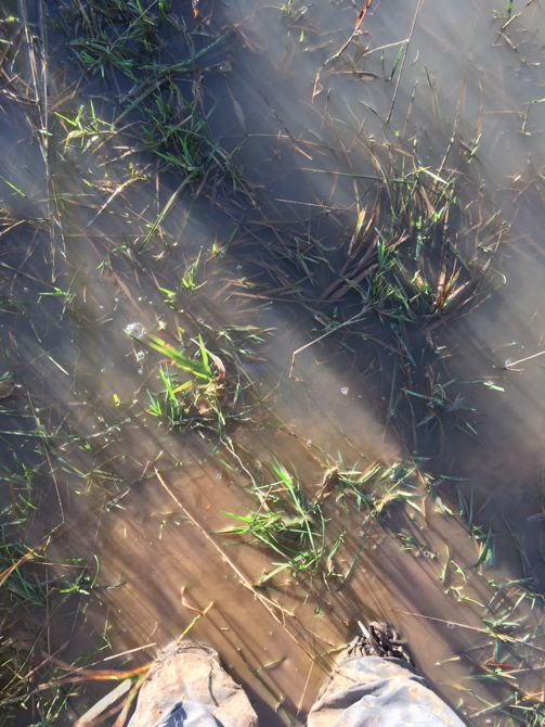
Thursday 24th December 2020 was the day I planned to complete Country Walking magazine‘s #walk2000miles challenge. Needing just under 13 miles to hit the 2000 miles target I selected the 18 miles East Leake Challenge as I felt this endurance walk would be a fitting conclusion and it would also be my tenth completion this year for this particular route. Since I measured it some time ago there have been recent diversions so I decided to use OS Maps App to get an accurate recording for the distance covered. Starting in East Leake and passing Brookside Primary School it isn’t long before a sharp ascent using steps the route goes through a kissing gate and onto Mill Hill. Even though this is high ground there were areas of the fields that were flooded. In the second field there is still evidence of the ridge and furrow farming system and I have tried on many occasions to photograph this particular landscape but unable to provide a visual record that conveyed this unusual feature.

However, today with low winter sunlight and strips of water flooding the dips I managed to achieve what I have been trying to do for a number of years. Crossing the road I went along the enclosed paths through the Manor Farm Donkey Sanctuary and as this walk was during the Christmas holiday period there were a few families roaming around having fun outside. After going over the footbridge which is on the border of the donkey sanctuary I immediately hit another flooded area and had to wade through. On reaching the site of St. Peter’s in the Rushes, a church demolished in around 1770, I paused to take some images of the old headstones.

Then I followed the diversion going through the Cemex quarry extension. This diversion isn’t to bad and at least one is walking on a green space. Around half way round this path I heard a noise from a skein of wild geese which was loud and almost deafening. They passed overhead as they circled the lakes formed in the old quarry workings and as they did I managed to take a couple of photographs. Passing All Saints’ Church, Rempstone I cross the A60 and follow the road round the corner to the White Lion pub to the next path. This has a short ascent to a hill but it levels out to gain views across the A60 and surrounding landscape. Just before the descent I removed my Patagonia insulated hoody and then I looked ahead to see if the path which crosses a field is not only visible but can be followed. On this occasion there wasn’t a clear line as the crops had been allowed to grow over the path. Taking the line of the path to the footbridge was muddy and rather squelchy. I felt that I could be stuck in a quagmire so I went across as quickly as I could. On the footway of the A60 for a short distance and then over the border into Leicestershire. A gap in the hedge allows access to the bridleway which follows King’s Brook on my right and the recently erected farm buildings on my left. As I turned to take the footpath I hit another flooded area and my boots were almost totally immersed in the water.
Finally, I made the ascent to the Hoton Hills where the highest point is 77 m above sea level. Following this high ground today’s sun provided clear views across the valley. Along this ridge I noticed a Kestrel hovering in the air with another one further into the valley. Then I looked across to the hedgerow only to observe a third Kestrel even closer. This was a time to pause and see these fine birds hunting. Arriving at the Ash tree where I found the ‘Fairy House’ last time I was delighted to see that not only was it still in situ but they have had visitors and evidence was that a feather, flower and painted stone had been left outside the door.
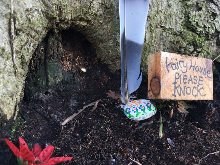
Now I know that people using this BW actually notice this ‘house’ which I find truly amazing. After descending the Hoton Ridge it wasn’t long before I was back into Nottinghamshire. Entering the village of Stanford on Soar the parish church of St. John the Baptist was highlighted by side lighting.

On passing the church I paused to take a photograph and then I continued along Stanford Road. After crossing the road bridge over the Great Central Railway line I ascend a few steps onto the field and followed the footpath which runs parallel to this line. At the field corner three discarded concrete pipes provide a reference point to turn left across the field and onto an enclosed lane which passes through Grange Farm. As I go through the farm yard I am greeted by the farmer who is pushing a wheel barrow and disappears into one of the cowsheds. On a side of an old outbuilding a mural has been painted and as the weather was so good I decided take a photograph but I could only see the top part due to a large white van obscuring the view. Suddenly, the farmer emerged and said that he would move the van so I could take a picture of the whole painting.

Once the van was moved I entered into a conversation and he told me that it was painted a couple of years ago by him and a friend who he was with at art college. She was over visiting him from New Orleans where she now lives and they both decided to do an abstract art work so that people passing through the farm could view the various images and make up their own ideas of what each part represents. Then we chatted about what we each saw in the picture and we both viewed different things when looking at the same areas which was his and his friend’s original idea. A family came by and were going down the wrong path. Both the farmer and I informed them of the correct route and then we talked about how people made mistakes when trying to follow a RoW whether they used an app or a paper map. The farmer and I must have been engaged in conversation for around twenty minutes. Then after wishing each other a Happy Christmas I continued onwards through the Limekiln Plantation to end at the A6006 which is close by the Cold Harbour triangulation pillar with the spot height of 80 m. At this point I took a photograph of the trig pillar before crossing the main road.

The bridleway gently descends and in the fields that have recently had grazing cattle but fortunately there wasn’t any today so I had a clear run. Through Manor Farm then just where I fork left on a BW there is a tree which has fallen across the path. However, it is easy to pass through and then I carried on to the bridge where I notice the brook has burst its banks and flooded the field I am walking in. The gate just before the bridge has a large puddle to negotiate which I manage to achieve.

Once on the bridge I take a few shots and then make my way to the bench in West Leake Church which is my planned lunch stop. Preparing to sit down on the bench I notice a chill in the air so put on my Patagonia insulated hoody. Lunch is just over 20 minutes and I know that at this point I am just over halfway into my journey. Taking the path which runs parallel with the road I start ascending Fox Hill and pass through the 95m contour line to reach the path junction with Crow Hill Wood. Here I join The Portway, an ancient track, to head NW passing Rushcliffe Golf course. Along the top sections of this route there are flooded areas and large puddles which make for interesting features to include in the photographs.

Leaving the golf course I eventually arrive at the Cuckoo Bush. This small wood houses a tumulus that is 3,000 years old and is believed to be the site of the original cuckoo bush from the Tales of the Wise Men of Gotham. Next there is a gradually steepening descent to negotiate and then this flattens out to cross the Gotham bypass and onto a track heading into the centre of Gotham village. Arriving at the village centre there is Christmas tree near the Well House.

I pause briefly for a drink and head out of the village using Moor Lane and then as I pass by an elderly couple the lady wishes me a ‘Happy Christmas’ and then all three of us engage in a conversation. I have met these before and they were interested in my quest to complete 2,000 miles which I said I would reach when I had finished this walk. The next section of this walk takes in both Gotham Moor and Bunny Moor. After the undulating landscape I recently encountered this section is flat and starts with a minor road then onto well defined trails which includes The Logan Trail, an old dismantled railway, and it is along this trail that I stop to take a picture of the ‘Hug Me’ sign nailed onto one of the trees.

After emerging from The Logan Trail the walk follows a bridleway along field boundaries, goes under a former Great Central Railway bridge, then after passing Welldale Farm takes a bridleway which crosses a middle of a field where an Ash tree growing in the centre provides a guide to the direction required.
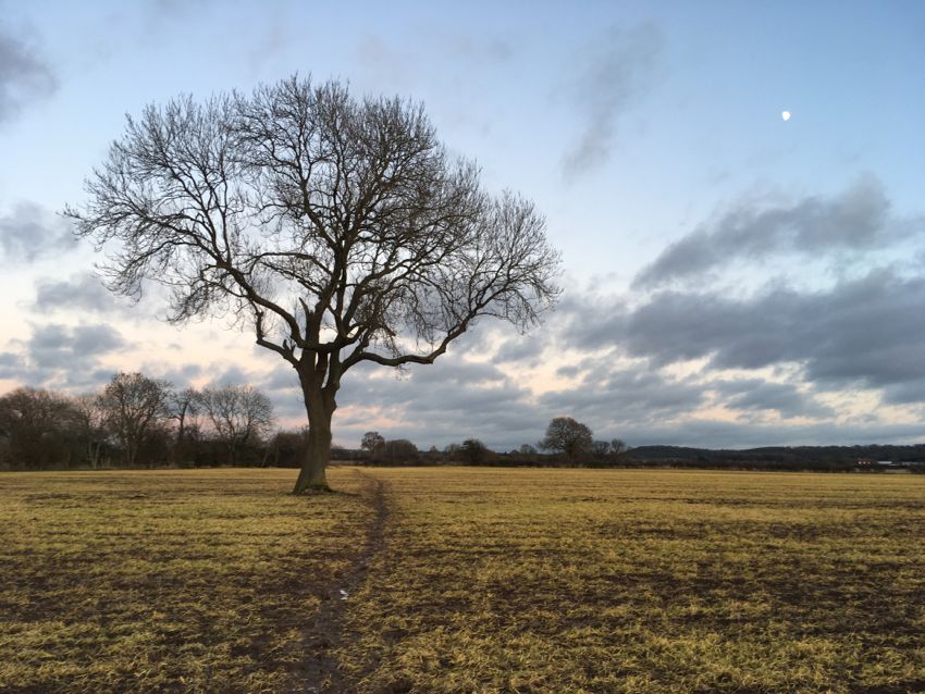
I always take at least one image of this tree on my excursions and I decided to take a few looking into the East where the sky was still light and into the West where the setting sun provided an almost silhouette of the tree. This BW now follows Fairham Brook until reaching a Willow tree by a footbridge. At this point I head south onto Gotham Lane and after crossing this road with care I ascend into New Wood on a path that gets muddier with every step. I cannot believe that just a couple of months ago this section was dry as a bone. Going through this belt of woodland the footpath heads SW to Ash Lane. Now the route heads west and then south.

On the descent I take a few photographs of the setting sun before picking up a path system running SW over Lantern Lane twice. Here I send a WhatsApp to Jane to let her know I am not far from the finish line. Now I take a lane running south to join an enclosed pathway. From this point there is no more mud and the way ahead is on tarmac paths and pavements. At the junction with the main road a small path leads into Meadow Park where I hit ‘The Highway’, a major path in the park, then onwards to the finish. When I arrive home my wife is waiting to greet and congratulate me on completing my #walk2000miles challenge in 2020.

Today I found this walk really challenging as my finishing time reflects with the reasons being the relentless mud in some of the sections along with the flooded areas but it was most satisfying to complete #walk2000miles on my tenth East Leake Challenge in 2020. The OS Maps App recorded 18.75miles for this route which matched closely the distance recorded by my iPhone SE which was 18.8 miles. The iPhone also noted that I did 42,674 steps for this activity.
#walk500miles challenge completed on 5th May
#walk1000miles challenge completed on 22nd July
#walk1500miles challenge completed on 30th September
#walk2000miles challenge completed on 24th December
